
1915 Map of Park Place
USGS Topo · Published 1915About this map
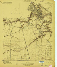
Buffalo Bayou and its industrial reaches dominate this 1915 survey of the southeast City of Houston. The map captures a critical era of maritime development centered on the Turning Basin and the emerging facilities at Port Houston. Settlement patterns follow the winding course of the bayous and the dense network of railroads, including the Houston Belt and Terminal and the International and Great Northern. Away from the urban core, the landscape transitions into the residential developments of Magnolia and Park Place, alongside older communities like Harrisburg. The importance of the rail-to-water transition is evident in features like South Yards and the various switches along the Gulf Colorado and Santa Fe line. Further south, the meandering Sims Bayou and Plumb Bayou cut through the terrain near Brookline and Kensington, showing the early 20th-century footprint of Harris County before modern suburban expansion.
Find a feature on this map
33 named features on this map. Tap any name to fly to it.
Don’t see what you’re looking for? This feature index may not catch every label — zoom into the map to look around manually.
Map Details
Editions of this 1915 Park Place Map
2 editions found
Other maps of this area

1915 · Bellaire
USGS Topo · 1:24,000

1915 · Houston Heights
USGS Topo · 1:24,000

1915 · Deepwater
USGS Topo · 1:24,000

1916 · Genoa
USGS Topo · 1:24,000

1916 · Settegast
USGS Topo · 1:24,000

1916 · Fauna
USGS Topo · 1:24,000

1919 · Deepwater
USGS Topo · 1:31,680

1920 · Genoa
USGS Topo · 1:31,680
1920 · Fauna
USGS Topo · 1:31,680

1920 · Mykawa
USGS Topo · 1:31,680