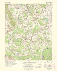
1963 Map of Park Place
USGS Topo · Published 1963About this map
St Francis River meanders through a landscape defined by complex hydrology and flood control efforts in the early 1960s. The terrain transitions from the elevated Crowley Ridge in the southwest to the broad, swampy bottomlands punctuated by numerous oxbows like Big Twin Lake and Little Yancopin Lake. The St Francis Floodway and various levees illustrate the mid-century engineering required to manage this portion of the Mississippi River delta.
Find a feature on this map
108 named features on this map. Tap any name to fly to it.
Don’t see what you’re looking for? This feature index may not catch every label — zoom into the map to look around manually.
Map Details
Editions of this 1963 Park Place Map
This is the sole edition of this map. No revisions or reprints were ever made.
Other maps of this area

1931 · Horseshoe Lake
USGS Topo · 1:62,500

1939 · Clayton
USGS Topo · 1:62,500

1939 · Horseshoe Lake
USGS Topo · 1:62,500

1939 · Park Place
USGS Topo · 1:62,500

1939 · Wynne
USGS Topo · 1:62,500

1939 · Edmondson
USGS Topo · 1:62,500

1939 · Latour
USGS Topo · 1:62,500

1940 · Marvell
USGS Topo · 1:62,500

1940 · Whitmore
USGS Topo · 1:62,500

1940 · Marianna
USGS Topo · 1:62,500