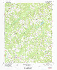
1972 Map of Park Spring
USGS Topo · Published 1990About this map
Hogans Creek and its various forks define the rolling landscape of Caswell County, North Carolina, during the early 1970s. The area maintains a traditional rural character, anchored by small settlements such as Bethel and Swann, while West Yanceyville sits on the eastern edge of the quadrangle. Transportation is centered on the Southern railroad line passing through Pelham, while a prominent Pipeline and the Caswell Airport signify modern infrastructure developments within the agricultural district.
Find a feature on this map
36 named features on this map. Tap any name to fly to it.
Don’t see what you’re looking for? This feature index may not catch every label — zoom into the map to look around manually.
Map Details
Editions of this 1972 Park Spring Map
3 editions found
Other maps of this area

1923 · Danville
USGS Topo · 1:48,000

1924 · Draper
USGS Topo · 1:48,000

1925 · Danville
USGS Topo · 1:62,500

1926 · Draper
USGS Topo · 1:62,500

1944 · Draper
USGS Topo · 1:62,500

1953 · Greensboro
USGS Topo · 1:250,000

1954 · Greensboro
USGS Topo · 1:250,000

1962 · Greensboro
USGS Topo · 1:250,000

1965 · Danville
USGS Topo · 1:24,000
1965 · Brosville
USGS Topo · 1:24,000