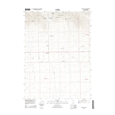
2014 Map of Park Valley
USGS Topo · Published 2014About this map
Park Valley serves as the primary focal point of this northern Utah landscape, situated at the base of the southern slopes of the Raft River Mountains. This 2014 survey reveals a high-desert environment characterized by long drainage systems and ranching operations, including the Hershey Ranch and C-Bar Ranch. Local history is anchored by the Park Valley Pioneer Cem and the Park Valley Cem, which sit just north of Ut-30. The topography transitions from the high peaks and steep ravines of Quaking Aspen Canyon and Little Rocky Canyon in the north down to the broader expanse of Chicken Ridge in the south. The area's hydrology is defined by seasonal watercourses like Cotton Cr and the various forks of Dunn Canyon, illustrating a classic Great Basin settlement pattern where life follows the reliable runoff from the mountain range.
Find a feature on this map
30 named features on this map. Tap any name to fly to it.
Don’t see what you’re looking for? This feature index may not catch every label — zoom into the map to look around manually.
Map Details
Editions of this 2014 Park Valley Map
This is the sole edition of this map. No revisions or reprints were ever made.
Other maps of this area

1954 · Brigham City
USGS Topo · 1:250,000

1958 · Brigham City
USGS Topo · 1:250,000

1959 · Kelton Pass
USGS Topo · 1:62,500

1959 · Park Valley
USGS Topo · 1:62,500

1962 · Brigham City
USGS Topo · 1:250,000

1969 · Peplin Flats
USGS Topo · 1:24,000
1971 · Runswick Wash
USGS Topo · 1:24,000
1971 · Russian Knoll
USGS Topo · 1:24,000

1987 · Grouse Creek
USGS Topo · 1:100,000
1990 · Rosette
USGS Topo · 1:24,000