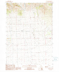
1990 Map of Park Valley
USGS Topo · Published 1990About this map
The northern slopes of the Raft River Mountains dominate this 1990 survey of Box Elder County, showing a landscape defined by dramatic elevation changes and remote water sources. The small settlement of Park Valley serves as the local hub, featuring an Athletic Field and a nearby Cem, while the surrounding terrain is deeply carved by drainages like Left Hand Fork Dunn Canyon and Cucchi Fork. Industrial activity is evident through a Quarry, Mine, and Gravel Pit, pointing to the area's resource extraction history. Significant landmarks such as Bald Knoll and the prominent Chicken Ridge provide orientation across the high-desert topography. Navigation through the more isolated sections of the quadrangle relies on a network of 4wd trails, which connect various remote Well sites and monitoring points like a Gaging Station and Radio Tower.
Find a feature on this map
26 named features on this map. Tap any name to fly to it.
Don’t see what you’re looking for? This feature index may not catch every label — zoom into the map to look around manually.
Map Details
Editions of this 1990 Park Valley Map
This is the sole edition of this map. No revisions or reprints were ever made.
Other maps of this area

1954 · Brigham City
USGS Topo · 1:250,000

1958 · Brigham City
USGS Topo · 1:250,000

1959 · Kelton Pass
USGS Topo · 1:62,500

1959 · Park Valley
USGS Topo · 1:62,500

1962 · Brigham City
USGS Topo · 1:250,000

1969 · Peplin Flats
USGS Topo · 1:24,000
1971 · Runswick Wash
USGS Topo · 1:24,000
1971 · Russian Knoll
USGS Topo · 1:24,000

1987 · Grouse Creek
USGS Topo · 1:100,000
1990 · Rosette
USGS Topo · 1:24,000