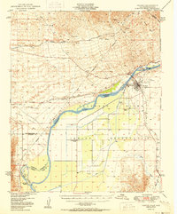
1950 Map of Parker
USGS Topo · Published 1950About this map
The Colorado River serves as the central artery and state boundary in this 1950 survey, defining the life and infrastructure of the Colorado River Indian Reservation. Centered on the town of Parker, the map details a landscape managed through hydraulic engineering, featuring the Headgate Rock Dam, an extensive network of canals, and a Siphon for irrigation. North of the river, the Whipple Mountains host industrial traces like the Blue Cloud Mine and Riverview Mine, while the desert floor is marked by the Aqueduct and the Atchison Topeka and Santa Fe railroad line passing through Earp and Vidal. Cultural landmarks of the era include the Indian Agency, the Colorado River Day Sch, and a designated Cremation Ground. The presence of the Parker Landing Field and various river channels like Alligator Slough illustrate the mid-century intersection of aviation, rail, and water management in the Arizona-California borderlands.
Find a feature on this map
34 named features on this map. Tap any name to fly to it.
Don’t see what you’re looking for? This feature index may not catch every label — zoom into the map to look around manually.
Map Details
Editions of this 1950 Parker Map
2 editions found

Other maps of this area

1911 · Parker
USGS Topo · 1:125,000

1930 · Linskey
USGS Topo · 1:62,500

1931 · Moon Mtn
USGS Topo · 1:62,500

1932 · Moon Mtn
USGS Topo · 1:62,500

1942 · Blythe
USGS Topo · 1:250,000

1942 · MOON MTN
USGS Topo · 1:62,500

1943 · Giers Basin
USGS Topo · 1:62,500

1943 · Whipple Mts.
USGS Topo · 1:62,500

1943 · Parker
USGS Topo · 1:62,500

1943 · Vidal
USGS Topo · 1:62,500