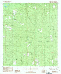
1982 Map of Parker Springs
USGS Topo · Published 1983About this map
Conecuh National Forest dominates this landscape in southern Alabama, where a network of creek branches and river prongs creates a complex drainage system through the timberlands. The settlement at Alaflora sits near the southern boundary, while the namesake Parker Springs is located centrally, marking a point of human activity within the dense forest. Small rural pockets like Camp Williams and Henley Roberts appear alongside family-named water features such as Mendenhall Creek and Foley Creek, reflecting the local genealogy and land use of Escambia County during the early 1980s.
Find a feature on this map
32 named features on this map. Tap any name to fly to it.
Don’t see what you’re looking for? This feature index may not catch every label — zoom into the map to look around manually.
Map Details
Editions of this 1982 Parker Springs Map
This is the sole edition of this map. No revisions or reprints were ever made.
Other maps of this area

1948 · Munson
USGS Topo · 1:62,500

1949 · Crestview
USGS Topo · 1:62,500

1950 · Munson
USGS Topo · 1:62,500

1951 · Crestview
USGS Topo · 1:62,500

1953 · Andalusia
USGS Topo · 1:250,000

1957 · Andalusia
USGS Topo · 1:250,000

1957 · Pensacola
USGS Topo · 1:250,000

1959 · Pensacola
USGS Topo · 1:250,000

1960 · Pensacola
USGS Topo · 1:250,000

1971 · Dixie
USGS Topo · 1:24,000