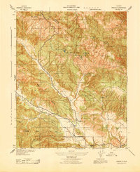
1943 Map of Parkfield
USGS Topo · Published 1943About this map
The settlement of Parkfield sits at the center of this 1943 War Department survey, serving as a hub for the surrounding ranching and mining country of southern Monterey County. The landscape is defined by the high ridges of Middle Mountain and the Cholame Hills, where the drainage of Cholame Creek and Little Cholame Creek dictates the placement of early homesteads and road networks. This era of the region’s history is marked by active resource extraction, evidenced by the Patriquin Quicksilver Mine and Poppy Mine located near Mine Mt.
Find a feature on this map
43 named features on this map. Tap any name to fly to it.
Don’t see what you’re looking for? This feature index may not catch every label — zoom into the map to look around manually.
Map Details
Editions of this 1943 Parkfield Map
This is the sole edition of this map. No revisions or reprints were ever made.
Other maps of this area

1912 · Coalinga
USGS Topo · 1:125,000

1914 · Cholame
USGS Topo · 1:125,000

1915 · Priest Valley
USGS Topo · 1:125,000

1915 · Cholame
USGS Topo · 1:125,000

1917 · Cholame
USGS Topo · 1:125,000

1919 · San Miguel
USGS Topo · 1:62,500

1934 · The Dark Hole
USGS Topo · 1:31,680

1936 · Kreyenhagen Hills
USGS Topo · 1:31,680
1937 · The Dark Hole
USGS Topo · 1:31,680
1941 · Kreyenhagen Hills
USGS Topo · 1:31,680