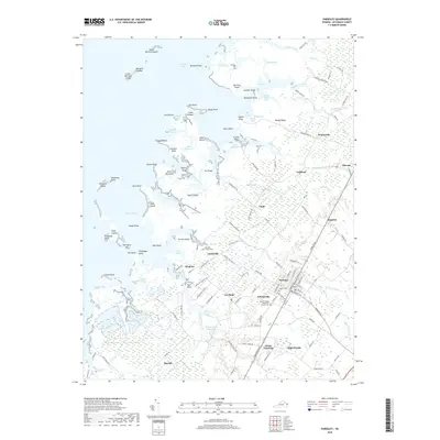
2019 Map of Parksley
USGS Topo · Published 2019About this map
Parksley serves as a central hub on this Virginia Eastern Shore landscape, where a grid of local roads and state routes connects long-established farming and maritime communities. The map details a complex coastal geography defined by the intricate waterways of Beasley Bay and the Little Back River, where numerous points and guts such as Simpson Point and Rue Gut suggest a life deeply tied to the tide. Family heritage is anchored in the land at the Abrams Family Cem near Justisville and Liberty Cem in the heart of town. Movement through the county follows historical corridors like Guards Shore Rd and Guilford Rd, linking inland settlements like Lee Mont and Whitesville to the marshy edges of the Chesapeake. The presence of Adams United Methodist Church and various small hamlets like Clam and Hopeton illustrates the enduring social fabric of Accomack County.
Find a feature on this map
155 named features on this map. Tap any name to fly to it.
Don’t see what you’re looking for? This feature index may not catch every label — zoom into the map to look around manually.
Map Details
Editions of this 2019 Parksley Map
This is the sole edition of this map. No revisions or reprints were ever made.
Other maps of this area

1903 · Crisfield
USGS Topo · 1:62,500

1920 · Crisfield
USGS Topo · 1:62,500

1931 · Accomac
USGS Topo · 1:48,000

1935 · Accomac
USGS Topo · 1:62,500

1942 · Chesconessex
USGS Topo · 1:31,680

1942 · Mappsville
USGS Topo · 1:24,000

1942 · Saxis
USGS Topo · 1:24,000

1942 · Parksley
USGS Topo · 1:24,000

1943 · Pungoteague
USGS Topo · 1:31,680

1943 · Parksley
USGS Topo · 1:31,680