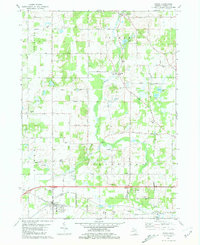
1981 Map of Parma
USGS Topo · Published 1981About this map
Parma and its agricultural surroundings appear in high detail during the early 1980s, centered on the Conrail line and the interstate corridor. The landscape is defined by the winding course of Sandstone Creek and Mackey Brook, which cut through a mosaic of woodlots and family-named roads like Mackie Road and Devereaux Road. Local history is anchored by numerous small cemeteries, including North Parma Cem, Pherdun Cem, and Lincoln Cem, suggesting the long-standing family lineages of the region.
Find a feature on this map
46 named features on this map. Tap any name to fly to it.
Don’t see what you’re looking for? This feature index may not catch every label — zoom into the map to look around manually.
Map Details
Editions of this 1981 Parma Map
This is the sole edition of this map. No revisions or reprints were ever made.
Other maps of this area

1919 · Springport
USGS Topo · 1:62,500

1919 · Rives Junction
USGS Topo · 1:62,500

1921 · Rives Junction
USGS Topo · 1:62,500

1921 · Springport
USGS Topo · 1:62,500

1935 · Jackson
USGS Topo · 1:48,000

1939 · Jackson
USGS Topo · 1:62,500

1948 · Spring Arbor
USGS Topo · 1:62,500

1949 · Spring Arbor
USGS Topo · 1:62,500

1958 · Grand Rapids
USGS Topo · 1:250,000

1961 · Grand Rapids
USGS Topo · 1:250,000