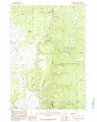
1984 Map of Parmlee Canyon
USGS Topo · Published 1984About this map
Black Hills National Forest straddles the border of Wyoming and South Dakota, where the drainage of Stockade Beaver Creek carves a series of deep ravines into the limestone plateaus. This 1984 provisional survey documents a landscape of intermittent water and remote outposts, centered on Mallo Camp near the state line. The terrain is defined by its canyons, from the winding Parmlee Canyon to the more open Prairie Springs Canyon to the west.
Find a feature on this map
24 named features on this map. Tap any name to fly to it.
Don’t see what you’re looking for? This feature index may not catch every label — zoom into the map to look around manually.
Map Details
Editions of this 1984 Parmlee Canyon Map
This is the sole edition of this map. No revisions or reprints were ever made.
Other maps of this area

1894 · Deadwood
USGS Topo · 1:125,000

1896 · Harney Peak
USGS Topo · 1:125,000

1898 · Sundance
USGS Topo · 1:125,000

1899 · Newcastle
USGS Topo · 1:125,000

1901 · Harney Peak
USGS Topo · 1:125,000

1901 · Deadwood
USGS Topo · 1:125,000

1901 · Newcastle
USGS Topo · 1:125,000

1902 · Sundance
USGS Topo · 1:125,000

1916 · Deadwood
USGS Topo · 1:125,000

1953 · Rapid City
USGS Topo · 1:250,000