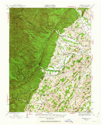
1944 Map of Parnassus
USGS Topo · Published 1963About this map
Narrow Back Mountain divides this mid-century landscape, where the agricultural flats of Glade Valley meet the dense ridges of the George Washington National Forest. In the east, the rural character of Augusta County and Rockingham County is defined by small crossroads like Sangerville, Parnassus, and Centerville, alongside local landmarks such as the Natural Chimneys and Fulton Sch. The western portion of the map is dominated by the steep slopes of Shenandoah Mountain, reaching its peak at Reddish Knob.
Find a feature on this map
88 named features on this map. Tap any name to fly to it.
Don’t see what you’re looking for? This feature index may not catch every label — zoom into the map to look around manually.
Map Details
Editions of this 1944 Parnassus Map
2 editions found

Other maps of this area

1892 · Franklin
USGS Topo · 1:125,000

1892 · Woodstock
USGS Topo · 1:125,000

1892 · Harrisonburg
USGS Topo · 1:125,000

1894 · Staunton
USGS Topo · 1:125,000

1896 · Franklin
USGS Topo · 1:125,000

1922 · Fort Seybert
USGS Topo · 1:48,000

1922 · Circleville
USGS Topo · 1:62,500

1924 · Circleville
USGS Topo · 1:48,000

1924 · Mc Dowell
USGS Topo · 1:62,500

1924 · Fort Seybert
USGS Topo · 1:62,500