
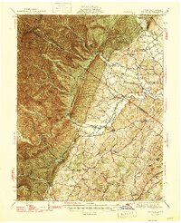
1947 Map of Parnassus
USGS Topo · Published 1947About this map
The striking limestone formations of Natural Chimneys stand as a central landmark in this 1940s survey of the Glade Valley region. Located where Augusta County meets Rockingham County, the landscape transition from the agricultural lowlands of Mt Solon and Parnassus to the high ridges of Shenandoah Mountain is clearly visible. The network of rural life is well-documented, showing small crossroads communities like Sangerville, Ottobine, and Centerville connected by a web of schools and churches such as Fulton Sch and Union Ch. To the west, the terrain becomes increasingly steep at North River Gap, where the North River emerges from the mountains near recreational sites like Hone Quarry Picnic Grounds and Camp May Flather (Girl Scouts). These details provide a clear view of the mid-century valley economy, centered on river drainage and gap-based transportation routes.
Find a feature on this map
71 named features on this map. Tap any name to fly to it.
Don’t see what you’re looking for? This feature index may not catch every label — zoom into the map to look around manually.
Map Details
Editions of this 1947 Parnassus Map
2 editions found
Other maps of this area

1892 · Franklin
USGS Topo · 1:125,000

1892 · Woodstock
USGS Topo · 1:125,000

1892 · Harrisonburg
USGS Topo · 1:125,000

1894 · Staunton
USGS Topo · 1:125,000

1896 · Franklin
USGS Topo · 1:125,000

1922 · Fort Seybert
USGS Topo · 1:48,000

1922 · Circleville
USGS Topo · 1:62,500

1924 · Circleville
USGS Topo · 1:48,000

1924 · Mc Dowell
USGS Topo · 1:62,500

1924 · Fort Seybert
USGS Topo · 1:62,500