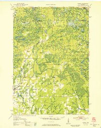
1952 Map of Parrish
USGS Topo · Published 1952About this map
Glacial topography and early twentieth-century rural development define this 1952 study of Langlade and Lincoln Counties. The landscape is characterized by a dense network of kettle lakes and wetlands, including Seven Island L and Big Lake, connected by numerous fire lanes. The influence of European immigration is visible in the presence of the Estonian Ch and Lettish Ch near the settlement of Gleason, reflecting the ethnic enclaves that shaped the Northwoods.
Find a feature on this map
89 named features on this map. Tap any name to fly to it.
Don’t see what you’re looking for? This feature index may not catch every label — zoom into the map to look around manually.
Map Details
Editions of this 1952 Parrish Map
This is the sole edition of this map. No revisions or reprints were ever made.
Other maps of this area
1899 · Wausau
USGS Topo · 1:125,000
1902 · Wausau
USGS Topo · 1:125,000
1939 · Cassian
USGS Topo · 1:48,000
1940 · Parrish
USGS Topo · 1:48,000
1940 · Monico
USGS Topo · 1:48,000
1940 · Rhinelander
USGS Topo · 1:48,000
1942 · Cassian
USGS Topo · 1:48,000
1942 · Elcho
USGS Topo · 1:48,000
1949 · Rhinelander
USGS Topo · 1:48,000
1950 · Monico
USGS Topo · 1:48,000