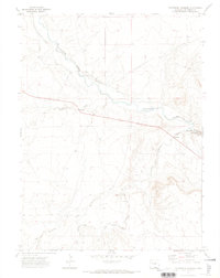
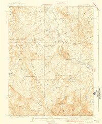
1971 Map of Parshall
USGS Topo · Published 1974About this map
The Purgatoire River carves a deep path through this portion of Las Animas County, serving as the primary geographical focus. At Patterson Crossing, the river’s winding course is accompanied by the Lewelling Mc Cormick Ditch, illustrating early water management and irrigation efforts in this arid landscape. The terrain is defined by dramatic elevation changes, culminating in the steep walls of Purgatoire Canyon to the east.
Find a feature on this map
14 named features on this map. Tap any name to fly to it.
Don’t see what you’re looking for? This feature index may not catch every label — zoom into the map to look around manually.
Map Details
Editions of this 1971 Parshall Map
This is the sole edition of this map. No revisions or reprints were ever made.
Other maps of this area
1933 · Mt. Powell
USGS Topo · 1:48,000
1933 · Ute Peak
USGS Topo · 1:62,500
1937 · Ute Peak
USGS Topo · 1:62,500
1940 · Mount Powell
USGS Topo · 1:62,500

1954 · Craig
USGS Topo · 1:250,000
1956 · Kremmling
USGS Topo · 1:62,500

1957 · Craig
USGS Topo · 1:250,000
1957 · Hot Sulphur Springs
USGS Topo · 1:62,500

1957 · Leadville
USGS Topo · 1:250,000

1958 · Craig
USGS Topo · 1:250,000