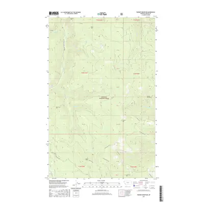
2017 Map of Parsnip Mountain
USGS Topo · Published 2017About this map
Kootenai National Forest dominates this landscape in Lincoln County, where the high ridges of the Purcell Mountains define the local topography. The map illustrates a network of drainage basins, with Parsnip Cr and its Middle Fork carving through the terrain near Parsnip Mountain. To the north, prominent summits like Pinto Point and Maxine Point stand over the headwaters of Copeland Cr and Maxine Cr. This 2017 survey details the integration of recreation and resource management, showing specialized transport routes such as the East Pipe/Big Creek Snowmobile trail and the Garden Ridge Snowmobile Spur. The map also traces Lawrence Mountain and Garden Ridge, providing a precise record of these landmarks within the national forest system.
Find a feature on this map
32 named features on this map. Tap any name to fly to it.
Don’t see what you’re looking for? This feature index may not catch every label — zoom into the map to look around manually.
Map Details
Editions of this 2017 Parsnip Mountain Map
This is the sole edition of this map. No revisions or reprints were ever made.
Other maps of this area

1957 · Kalispell
USGS Topo · 1:250,000

1960 · Kalispell
USGS Topo · 1:250,000

1961 · Kalispell
USGS Topo · 1:250,000

1963 · Pink Mountain
USGS Topo · 1:24,000

1963 · Banfield Mountain
USGS Topo · 1:24,000

1963 · Webb Mountain
USGS Topo · 1:24,000

1963 · Boulder Lakes
USGS Topo · 1:24,000
1963 · Inch Mountain
USGS Topo · 1:24,000

1963 · Lost Horse Mountain
USGS Topo · 1:24,000
1963 · Gold Hill
USGS Topo · 1:24,000