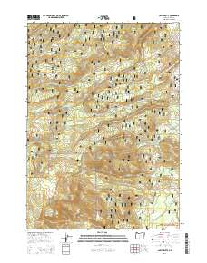
2014 Map of Partin Butte
USGS Topo · Published 2014About this map
Fremont National Forest defines the character of this high-elevation landscape, where a network of drainage systems feeds the larger basins of Lake County. The terrain is marked by significant volcanic features such as Partin Butte and Round Butte, which rise above the surrounding slopes of Alder Spring Ridge. Water management and natural springs are central to the geography here, evidenced by named points like Alder Spring and Partin Spring. The area's hydrology is complex, with headwaters for W Fork Silver Cr, Guyer Cr, and Strawberry Cr carving through the timbered sections. Access is provided by several established routes, including Natl Forest Develop Road 3021 Rd, which skirts the ridges. This 2014 survey documents the remote drainage patterns of the high desert fringe, illustrating how water travels from the heights toward Indian Creek Flat.
Find a feature on this map
22 named features on this map. Tap any name to fly to it.
Don’t see what you’re looking for? This feature index may not catch every label — zoom into the map to look around manually.
Map Details
Editions of this 2014 Partin Butte Map
This is the sole edition of this map. No revisions or reprints were ever made.
Other maps of this area

1889 · Klamath
USGS Topo · 1:250,000

1894 · Klamath
USGS Topo · 1:250,000

1955 · Crescent
USGS Topo · 1:250,000

1955 · Klamath Falls
USGS Topo · 1:250,000

1957 · Crescent
USGS Topo · 1:250,000

1958 · Crescent
USGS Topo · 1:250,000

1958 · Klamath Falls
USGS Topo · 1:250,000

1960 · Sycan Marsh
USGS Topo · 1:62,500

1960 · Yamsay Mountain
USGS Topo · 1:62,500

1968 · Rodman Rock
USGS Topo · 1:24,000