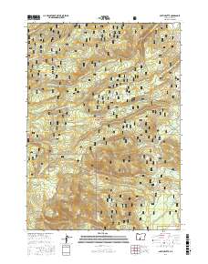
2017 Map of Partin Butte
USGS Topo · Published 2017About this map
Partin Butte and Round Butte define this high-altitude landscape within the Fremont National Forest of Lake County. This 2017 survey details the complex network of mountain drainages that feed the Silver Creek watershed, including N Fork Silver Cr, W Fork Silver Cr, and Strawberry Cr. The map highlights a remote area shaped by forest management and outdoor transit, notably featuring the Southern Oregon Intertie Trail as it traverses the western slopes. Evidence of localized water sources is found at Alder Spring near Alder Spring Ridge and further east at Partin Spring. Researchers can trace the intersections of several National Forest Development Roads, such as Natl Forest Develop Road 3142 RD, which provide modern access to landmarks like Indian Creek Flat.
Find a feature on this map
24 named features on this map. Tap any name to fly to it.
Don’t see what you’re looking for? This feature index may not catch every label — zoom into the map to look around manually.
Map Details
Editions of this 2017 Partin Butte Map
This is the sole edition of this map. No revisions or reprints were ever made.
Other maps of this area

1889 · Klamath
USGS Topo · 1:250,000

1894 · Klamath
USGS Topo · 1:250,000

1955 · Crescent
USGS Topo · 1:250,000

1955 · Klamath Falls
USGS Topo · 1:250,000

1957 · Crescent
USGS Topo · 1:250,000

1958 · Crescent
USGS Topo · 1:250,000

1958 · Klamath Falls
USGS Topo · 1:250,000

1960 · Sycan Marsh
USGS Topo · 1:62,500

1960 · Yamsay Mountain
USGS Topo · 1:62,500

1968 · Rodman Rock
USGS Topo · 1:24,000