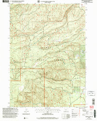
2004 Map of Partin Butte
USGS Topo · Published 2007About this map
Fremont National Forest defines the character of this high-elevation landscape in Lake County, where the terrain is shaped by volcanic buttes and a network of seasonal watercourses. The map reveals a land utilized for both utility and remote shelter, evidenced by the Oregon Southern Intertie corridor passing through the drainage of Silver Creek. Significant landmarks like Partin Butte and Round Butte rise above the surrounding slopes, while localized water sources such as Cougar Spring and Alder Spring provided essential stopovers for early travelers and foresters.
Find a feature on this map
39 named features on this map. Tap any name to fly to it.
Don’t see what you’re looking for? This feature index may not catch every label — zoom into the map to look around manually.
Map Details
Editions of this 2004 Partin Butte Map
This is the sole edition of this map. No revisions or reprints were ever made.
Other maps of this area

1889 · Klamath
USGS Topo · 1:250,000

1894 · Klamath
USGS Topo · 1:250,000

1955 · Crescent
USGS Topo · 1:250,000

1955 · Klamath Falls
USGS Topo · 1:250,000

1957 · Crescent
USGS Topo · 1:250,000

1958 · Crescent
USGS Topo · 1:250,000

1958 · Klamath Falls
USGS Topo · 1:250,000

1960 · Sycan Marsh
USGS Topo · 1:62,500

1960 · Yamsay Mountain
USGS Topo · 1:62,500

1968 · Rodman Rock
USGS Topo · 1:24,000