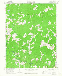
1966 Map of Partlow
USGS Topo · Published 1967About this map
North Anna River defines the southern boundary of this rural Piedmont landscape in the mid-1960s, where three counties—Spotsylvania, Louisa, and Hanover—meet at the river's edge. The area is characterized by a network of small crossroads communities and family-named landmarks that hint at a deep-rooted agricultural history. Long-standing local congregations are anchored at Wallers Ch and St Johns Ch, while the educational needs of the northern district were served by the Livingston Sch.
Find a feature on this map
30 named features on this map. Tap any name to fly to it.
Don’t see what you’re looking for? This feature index may not catch every label — zoom into the map to look around manually.
Map Details
Editions of this 1966 Partlow Map
This is the sole edition of this map. No revisions or reprints were ever made.
Other maps of this area

1887 · Spottsylvania
USGS Topo · 1:125,000

1890 · Goochland
USGS Topo · 1:125,000

1892 · Spottsylvania
USGS Topo · 1:125,000

1892 · Goochland
USGS Topo · 1:125,000

1942 · Ladysmith
USGS Topo · 1:31,680

1942 · Partlow
USGS Topo · 1:31,680

1942 · Belmont
USGS Topo · 1:31,680

1942 · Contrary Creek
USGS Topo · 1:31,680

1942 · Spotsylania
USGS Topo · 1:31,680

1942 · Brokenburg
USGS Topo · 1:31,680