1991 Map of Partoun
USGS Topo · Published 1991About this map
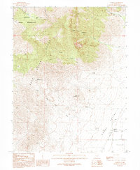
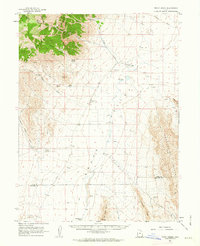
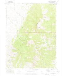
The Deep Creek Range dominates the western landscape of this Juab County region, giving way to the expansive desert flats of the Snake Valley to the east. This 1991 map illustrates a remote high-desert environment where water sources like Blue Spring and Trough Spring were critical for sustaining life and travel. To the northwest, the map shows a portion of the Goshute Indian Reservation, marking the indigenous presence and sovereignty in this arid territory. The small settlement of Partoun sits along the Gandy Road, serving as a focal point for the local community with its West Desert Sch. The terrain transitions from the steep, rugged drainage of Wood Canyon and The Narrows down through the Little Red Cedar Wash toward the valley floor, where industrial Gravel Pits indicate local resource extraction during the late 20th century.
Find a feature on this map
24 named features on this map. Tap any name to fly to it.
Don’t see what you’re looking for? This feature index may not catch every label — zoom into the map to look around manually.
Map Details
Editions of this 1991 Partoun Map
This is the sole edition of this map. No revisions or reprints were ever made.
Other maps of this area

1908 · Fish Springs
USGS Topo · 1:250,000

1910 · Fish Springs
USGS Topo · 1:250,000

1953 · Delta
USGS Topo · 1:250,000

1956 · Ely
USGS Topo · 1:250,000

1958 · Delta
USGS Topo · 1:250,000

1959 · Ely
USGS Topo · 1:250,000
1961 · Trout Creek
USGS Topo · 1:62,500

1962 · Delta
USGS Topo · 1:250,000

1963 · Ely
USGS Topo · 1:250,000
1972 · Ibapah Peak
USGS Topo · 1:24,000