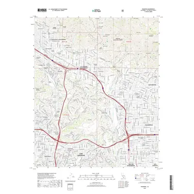
2018 Map of Pasadena
USGS Topo · Published 2018About this map
Pasadena and its neighboring communities in the San Gabriel Valley are depicted here during a period of dense urban integration alongside the preserved wildlands of the Angeles National Forest. The map illustrates the sophisticated educational and scientific landscape of the region, anchored by the California Institute of Technology (Caltech), Occidental College, and the California School of Culinary Arts. The transition from the developed valley floor to the steep southern front of the San Gabriel Mountains is starkly visible, with numerous canyons like Millard Canyon and El Prieto Canyon cutting through the terrain above Altadena. Historical land divisions are noted through township markers such as t1n r12w, while the intricate water management system is shown through features like the Devils Gate Reservoir and the Arroyo Seco channel, which serves as a central geographical spine for the area's development and parklands.
Find a feature on this map
85 named features on this map. Tap any name to fly to it.
Don’t see what you’re looking for? This feature index may not catch every label — zoom into the map to look around manually.
Map Details
Editions of this 2018 Pasadena Map
This is the sole edition of this map. No revisions or reprints were ever made.
Other maps of this area

1894 · Los Angeles
USGS Topo · 1:62,500

1896 · Pasadena
USGS Topo · 1:62,500

1896 · Santa Monica
USGS Topo · 1:62,500

1898 · Santa Monica
USGS Topo · 1:62,500

1900 · Pasadena
USGS Topo · 1:62,500

1900 · Tujunga
USGS Topo · 1:62,500

1900 · Los Angeles
USGS Topo · 1:62,500

1900 · Fernando
USGS Topo · 1:62,500

1901 · Southern California Sheet No. 1
USGS Topo · 1:250,000

1902 · Santa Monica
USGS Topo · 1:62,500