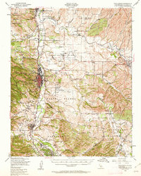
1948 Map of Paso Robles
USGS Topo · Published 1962About this map
Paso Robles and the surrounding agricultural heart of San Luis Obispo County are captured here just after the post-war shift in regional aviation and infrastructure. The Salinas River valley serves as the primary corridor for the Southern Pacific railroad and U S Highway 101, connecting a string of rural hubs including San Miguel, Templeton, and Atascadero. The landscape is a mix of alluvial terraces like San Lawrence Terrace and canyon-cut hillsides, where numerous windmills signify a deep reliance on groundwater for the local ranching and farming economy.
Find a feature on this map
50 named features on this map. Tap any name to fly to it.
Don’t see what you’re looking for? This feature index may not catch every label — zoom into the map to look around manually.
Map Details
Editions of this 1948 Paso Robles Map
2 editions found
Other maps of this area

1897 · San Luis Obispo
USGS Topo · 1:62,500

1897 · Cayucos
USGS Topo · 1:62,500

1900 · San Luis
USGS Topo · 1:125,000

1914 · Cholame
USGS Topo · 1:125,000

1915 · Cholame
USGS Topo · 1:125,000

1917 · Cholame
USGS Topo · 1:125,000

1919 · San Miguel
USGS Topo · 1:62,500

1919 · Paso Robles
USGS Topo · 1:62,500

1919 · Bradley
USGS Topo · 1:62,500

1919 · Adelaida
USGS Topo · 1:62,500