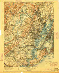
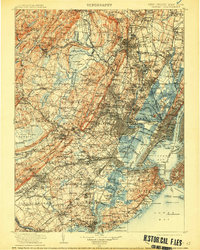
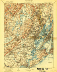
1905 Map of Passaic
USGS Topo · Published 1909About this map
The Morris Canal winds through a landscape of rapid industrialization and expansion at the turn of the century, connecting the waters of the Passaic River and Hackensack River with the bustling harbors of the Upper Bay. This survey captures the dense rail network of the era, where the Morris and Essex R.R. and Lehigh Valley R.R. converge near the maritime hubs of Newark and Elizabeth. To the south, the defenses of The Narrows are clearly marked by Fort Wadsworth and Fort Hamilton, guarding the passage between Staten Island and Brooklyn. The interior reveals a transition from the urban centers of Jersey City to the more open terrain surrounding Morristown and the Great Swamp, while significant harbor landmarks like Ellis Id. and Liberty Id. stand at the gateway to the Hudson River.
Find a feature on this map
374 named features on this map. Tap any name to fly to it.
Don’t see what you’re looking for? This feature index may not catch every label — zoom into the map to look around manually.
Map Details
Editions of this 1905 Passaic Map
4 editions found

Other maps of this area

1888 · Franklin
USGS Topo · 1:62,500

1888 · Plainfield
USGS Topo · 1:62,500

1888 · Morristown
USGS Topo · 1:62,500

1888 · New Brunswick
USGS Topo · 1:62,500

1888 · Princeton
USGS Topo · 1:62,500

1888 · Lake Hopatcong
USGS Topo · 1:62,500

1888 · Paterson
USGS Topo · 1:62,500

1888 · Sandy Hook
USGS Topo · 1:62,500

1889 · Brooklyn
USGS Topo · 1:62,500

1891 · Somerville
USGS Topo · 1:62,500