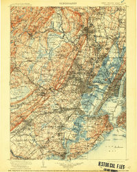
1905 Map of Passaic
USGS Topo · Published 1913About this map
The Morris Canal and Raritan Canal serve as industrial arteries for Northern New Jersey at a time of massive urban expansion, cutting across the ridge-and-valley terrain of the Stony Brook Mountains and First Mountain. This 1905 survey reveals a landscape of dense rail networks, including the Erie R.R. and Lehigh Valley R.R., which facilitated the movement of goods and people between emerging commuter suburbs like Convent Sta. and the bustling hubs of Newark and Jersey City.
Find a feature on this map
323 named features on this map. Tap any name to fly to it.
Don’t see what you’re looking for? This feature index may not catch every label — zoom into the map to look around manually.
Map Details
Editions of this 1905 Passaic Map
4 editions found
Other maps of this area

1888 · Franklin
USGS Topo · 1:62,500

1888 · Plainfield
USGS Topo · 1:62,500

1888 · Morristown
USGS Topo · 1:62,500

1888 · New Brunswick
USGS Topo · 1:62,500

1888 · Princeton
USGS Topo · 1:62,500

1888 · Lake Hopatcong
USGS Topo · 1:62,500

1888 · Paterson
USGS Topo · 1:62,500

1888 · Sandy Hook
USGS Topo · 1:62,500

1889 · Brooklyn
USGS Topo · 1:62,500

1891 · Somerville
USGS Topo · 1:62,500