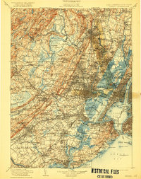
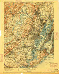
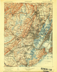
1905 Map of Passaic
USGS Topo · Published 1922About this map
The Passaic River and the complex tidal waterways of Newark Bay anchor this detailed study of the industrial heart of the New York and New Jersey metropolitan region. This era reveals a landscape defined by an incredibly dense network of competing rail lines, including the Erie R.R. and the Lehigh Valley R.R., which facilitated the rapid growth of settlements from Montclair to Elizabeth. The maritime importance of the harbor is highlighted by essential navigational aids such as the Robbins Reef Light and the Passaic Light, while the military defenses of The Narrows are clearly marked by Fort Wadsworth, Fort Tompkins, and Fort Hamilton. Beyond the urban core, the map captures the varied terrain of the Watchung Mountains and the distinctive wetlands of the Great Swamp, showing the contrast between the burgeoning suburban developments in places like Maplewood and the more open terrain of Morris County and the Pequannock Mountains.
Find a feature on this map
390 named features on this map. Tap any name to fly to it.
Don’t see what you’re looking for? This feature index may not catch every label — zoom into the map to look around manually.
Map Details
Editions of this 1905 Passaic Map
4 editions found

Other maps of this area

1888 · Franklin
USGS Topo · 1:62,500

1888 · Plainfield
USGS Topo · 1:62,500

1888 · Morristown
USGS Topo · 1:62,500

1888 · New Brunswick
USGS Topo · 1:62,500

1888 · Princeton
USGS Topo · 1:62,500

1888 · Lake Hopatcong
USGS Topo · 1:62,500

1888 · Paterson
USGS Topo · 1:62,500

1888 · Sandy Hook
USGS Topo · 1:62,500

1889 · Brooklyn
USGS Topo · 1:62,500

1891 · Somerville
USGS Topo · 1:62,500