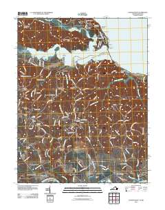
2011 Map of Passapatanzy
USGS Topo · Published 2011About this map
The Potomac River and its intricate tributaries dominate this landscape, where the peninsula of Marlborough Neck reaches toward the water between Accokeek Creek and Potomac Creek. This 2011 survey records a dense network of riverside landings and residential developments, from the established neighborhood of Passapatanzy to coastal points like Montague Landing and Crows Nest Point. Inland, the terrain is defined by a series of small, family-named crossroads and communities such as Johnsons Corner, Cox Corner, and Gayles. Local history and genealogy researchers will find several well-marked burial sites, including Bethel Cemetery, Bethlehem Cemetery, and Fletchers Chapel Cemetery, which anchor the rural landscape. The southern boundary is traced by the Rappahannock River, highlighting the area's historical reliance on these major waterways for commerce and connection.
Find a feature on this map
148 named features on this map. Tap any name to fly to it.
Don’t see what you’re looking for? This feature index may not catch every label — zoom into the map to look around manually.
Map Details
Editions of this 2011 Passapatanzy Map
This is the sole edition of this map. No revisions or reprints were ever made.
Other maps of this area

1889 · Fredericksburg
USGS Topo · 1:125,000

1892 · Fredericksburg
USGS Topo · 1:125,000

1894 · Fredericksburg
USGS Topo · 1:125,000

1913 · Nanjemoy
USGS Topo · 1:62,500

1926 · Stafford
USGS Topo · 1:62,500

1931 · Stafford
USGS Topo · 1:62,500

1942 · Guinea
USGS Topo · 1:31,680

1942 · Port Royal
USGS Topo · 1:31,680

1942 · Rappahannock Academy
USGS Topo · 1:31,680
1943 · Fredericksburg
USGS Topo · 1:24,000