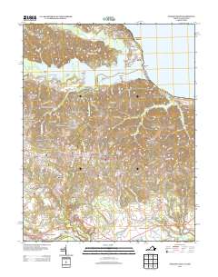
2013 Map of Passapatanzy
USGS Topo · Published 2013About this map
Passapatanzy and its surrounding King George County landscape are defined by the intricate waterways between the Potomac River and the Rappahannock River. This 2013 survey illustrates a region where residential development, such as Woodlanding Village and Potomac Knolls, is integrated into a geography of historical landings and prominent river points. Landmarks like Crows Nest Point, Marlboro Point, and Whipsawasons Point jut into Potomac Cr, while inland settlements like Sealston and Johnsons Corner anchor the crossroads. The map reveals the persistence of family-named corners and landings, from Butzner Corner near the southern riverbend to Knotsmythes Landing on the western creeks. These features, alongside named tracts like The Holly Woods, highlight the transition from traditional riverfront industry to a modern residential and recreational character, exemplified by the Waugh Point Marina.
Find a feature on this map
121 named features on this map. Tap any name to fly to it.
Don’t see what you’re looking for? This feature index may not catch every label — zoom into the map to look around manually.
Map Details
Editions of this 2013 Passapatanzy Map
This is the sole edition of this map. No revisions or reprints were ever made.
Other maps of this area

1889 · Fredericksburg
USGS Topo · 1:125,000

1892 · Fredericksburg
USGS Topo · 1:125,000

1894 · Fredericksburg
USGS Topo · 1:125,000

1913 · Nanjemoy
USGS Topo · 1:62,500

1926 · Stafford
USGS Topo · 1:62,500

1931 · Stafford
USGS Topo · 1:62,500

1942 · Guinea
USGS Topo · 1:31,680

1942 · Port Royal
USGS Topo · 1:31,680

1942 · Rappahannock Academy
USGS Topo · 1:31,680
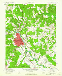
1943 · Fredericksburg
USGS Topo · 1:24,000