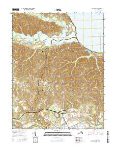
2016 Map of Passapatanzy
USGS Topo · Published 2016About this map
Passapatanzy and the surrounding rural landscape of King George and Stafford Counties are defined by the convergence of the Potomac Creek and the Potomac River. The terrain is characterized by prominent peninsulas and necks, including Marlborough Neck and Crows Nest Point, which reach into the wide waters near Fairview Beach. Local genealogy is well-represented through numerous historical burial grounds, such as Bethel Cem, Bethlehem Cem, and Union Belle Cem, often situated near small inland communities like White Oak and Sealston. The map illustrates the transition from the marshy lowlands of Big Marsh and Black Swamp to the residential corridors along Belle Plains Rd. Further south, the landscape is marked by the course of the Rappahannock River and the tributaries of Lambs Creek, showing the traditional settlement patterns of the Virginia Tidewater region.
Find a feature on this map
139 named features on this map. Tap any name to fly to it.
Don’t see what you’re looking for? This feature index may not catch every label — zoom into the map to look around manually.
Map Details
Editions of this 2016 Passapatanzy Map
This is the sole edition of this map. No revisions or reprints were ever made.
Other maps of this area

1889 · Fredericksburg
USGS Topo · 1:125,000

1892 · Fredericksburg
USGS Topo · 1:125,000

1894 · Fredericksburg
USGS Topo · 1:125,000

1913 · Nanjemoy
USGS Topo · 1:62,500

1926 · Stafford
USGS Topo · 1:62,500

1931 · Stafford
USGS Topo · 1:62,500

1942 · Guinea
USGS Topo · 1:31,680

1942 · Port Royal
USGS Topo · 1:31,680

1942 · Rappahannock Academy
USGS Topo · 1:31,680
1943 · Fredericksburg
USGS Topo · 1:24,000