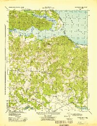
1944 Map of Passapatanzy
USGS Topo · Published 1944About this map
Potomac Creek and the Potomac River define the northern landscape of this wartime survey, where established waterfront landings like Spillmans Ldg and Marlboro Pt reflect the long-standing maritime reliance of the Virginia neck. Inland, the map reveals a rural community anchored by small post offices and neighborhood churches, such as Passapatanzy, Goby PO, and Fletcher Chapel. A notable wartime addition is the U. S. Government Railroad, which cuts through the southern portion of the sheet near Sealston Station, signifying the military importance of this region during the 1940s. The presence of the Whipsewason Club House and various named points like Pratts Pt suggests a blend of private recreation and commercial river access. Local researchers will find the specific placement of rural landmarks like Bethel Ch and Union Bell Ch invaluable for tracing family history and old property boundaries between Stafford and King George counties.
Find a feature on this map
37 named features on this map. Tap any name to fly to it.
Don’t see what you’re looking for? This feature index may not catch every label — zoom into the map to look around manually.
Map Details
Editions of this 1944 Passapatanzy Map
This is the sole edition of this map. No revisions or reprints were ever made.
Other maps of this area

1889 · Fredericksburg
USGS Topo · 1:125,000

1892 · Fredericksburg
USGS Topo · 1:125,000

1894 · Fredericksburg
USGS Topo · 1:125,000

1913 · Nanjemoy
USGS Topo · 1:62,500

1926 · Stafford
USGS Topo · 1:62,500

1931 · Stafford
USGS Topo · 1:62,500

1942 · Guinea
USGS Topo · 1:31,680

1942 · Port Royal
USGS Topo · 1:31,680

1942 · Rappahannock Academy
USGS Topo · 1:31,680
1943 · Fredericksburg
USGS Topo · 1:24,000