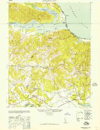
1952 Map of Passapatanzy
USGS Topo · Published 1952About this map
Potomac Creek and its many wooded branches define this 1952 topographic study of the borderlands between Stafford and King George counties. The landscape transitions from the riverfront landings and bluffs like Bull Bluff down to the rail corridor of the U S Government Railroad in the south. This era shows a network of small rural crossroads and post offices such as Goby PO and Igo PO, alongside several established country congregations including Fletcher Chapel and Mt Moriah Ch. Near the water, landmarks like the Whipsewason Club House and the riverfront at Belvedere Beach suggest a mid-century character tied to the Potomac River shoreline. Farther inland, the map captures the transition to agriculture and small community hubs around Sealston PO and the rural education center at Lambs Creek Sch.
Find a feature on this map
43 named features on this map. Tap any name to fly to it.
Don’t see what you’re looking for? This feature index may not catch every label — zoom into the map to look around manually.
Map Details
Editions of this 1952 Passapatanzy Map
This is the sole edition of this map. No revisions or reprints were ever made.
Other maps of this area

1889 · Fredericksburg
USGS Topo · 1:125,000

1892 · Fredericksburg
USGS Topo · 1:125,000

1894 · Fredericksburg
USGS Topo · 1:125,000

1913 · Nanjemoy
USGS Topo · 1:62,500

1926 · Stafford
USGS Topo · 1:62,500

1931 · Stafford
USGS Topo · 1:62,500

1942 · Guinea
USGS Topo · 1:31,680

1942 · Port Royal
USGS Topo · 1:31,680

1942 · Rappahannock Academy
USGS Topo · 1:31,680
1943 · Fredericksburg
USGS Topo · 1:24,000