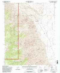
1994 Map of Pat Keyes Canyon
USGS Topo · Published 1997About this map
Inyo Mountains terrain dominates this 1994 survey, where the steep desert slopes drop sharply toward the Saline Valley. The landscape is defined by a network of deep drainages including Pat Keyes Canyon and McEvoy Canyon, which are fed by isolated water sources like Pat Keyes Spring and the Badwater Springs. The map documents a history of resource extraction, particularly near Willow Creek Camp, where the White Eagle Mine and Gray Eagle Mine are located alongside various prospects. An unusual Cableway and a remote Landing Strip indicate the logistical challenges of operating in this environment. The Inyo National Forest Wilderness Boundary cuts through the western portion of the sheet, marking a transition from managed national forest land to protected wilderness.
Find a feature on this map
27 named features on this map. Tap any name to fly to it.
Don’t see what you’re looking for? This feature index may not catch every label — zoom into the map to look around manually.
Map Details
Editions of this 1994 Pat Keyes Canyon Map
2 editions found
Other maps of this area

1907 · Mt. Whitney
USGS Topo · 1:125,000

1908 · Ballarat
USGS Topo · 1:250,000

1913 · Ballarat
USGS Topo · 1:250,000

1919 · Mt. Whitney
USGS Topo · 1:125,000

1937 · Mt. Whitney
USGS Topo · 1:125,000

1948 · Death Valley
USGS Topo · 1:250,000

1948 · Fresno
USGS Topo · 1:250,000

1950 · New York Butte
USGS Topo · 1:62,500

1951 · New York Butte
USGS Topo · 1:62,500

1951 · Waucoba Wash
USGS Topo · 1:62,500