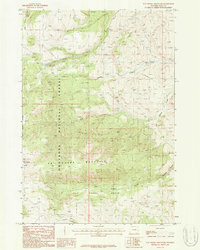
1987 Map of Pat O' Hara Mountain
USGS Topo · Published 1987About this map
Pat O'Hara Mountain dominates this portion of the Shoshone National Forest, rising above the high-elevation drainage of the Pat O'Hara Basin. The landscape is defined by its deep drainages and sharp relief, including the prominent Pat O'Hara Peak and the complex terrain of Oxyoke Canyon. This 1980s survey documents a wilderness environment largely shaped by natural features rather than permanent human settlement.
Find a feature on this map
15 named features on this map. Tap any name to fly to it.
Don’t see what you’re looking for? This feature index may not catch every label — zoom into the map to look around manually.
Map Details
Editions of this 1987 Pat O' Hara Mountain Map
This is the sole edition of this map. No revisions or reprints were ever made.
Other maps of this area

1949 · Pat O'Hara Mountain
USGS Topo · 1:62,500

1949 · Cody
USGS Topo · 1:62,500

1950 · Clark
USGS Topo · 1:62,500

1950 · Deep Lake
USGS Topo · 1:62,500

1951 · Cody
USGS Topo · 1:62,500

1955 · Cody
USGS Topo · 1:250,000

1958 · Cody
USGS Topo · 1:250,000

1962 · Cody
USGS Topo · 1:250,000

1980 · Cody
USGS Topo · 1:100,000
1987 · Jim Mountain
USGS Topo · 1:24,000