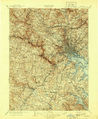
1908 Map of Patapsco
USGS Topo · Published 1944About this map
The Patapsco River and its multiple branches anchor this early 20th-century landscape, revealing a region defined by its radiating transportation corridors and historic institutional footprints. The city of Baltimore stands as a dense urban core, guarded by Fort McHenry and Fort Carroll, while a network of turnpikes like the Frederick Turnpike and Columbia Turnpike stretch into the surrounding valleys. These lowlands, including the Worthington Valley and Long Green Valley, are dotted with established rural settlements and significant landmarks such as St Charles College and the McDonogh School.
Find a feature on this map
124 named features on this map. Tap any name to fly to it.
Don’t see what you’re looking for? This feature index may not catch every label — zoom into the map to look around manually.
Map Details
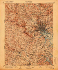
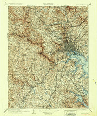
Editions of this 1908 Patapsco Map
4 editions found

Other maps of this area

1890 · Mt. Vernon
USGS Topo · 1:125,000

1891 · Mt. Vernon
USGS Topo · 1:125,000

1892 · Laurel
USGS Topo · 1:62,500

1892 · Ellicott
USGS Topo · 1:62,500

1892 · Owensville
USGS Topo · 1:62,500

1892 · Annapolis
USGS Topo · 1:62,500

1893 · North Point
USGS Topo · 1:62,500

1893 · Gunpowder
USGS Topo · 1:62,500

1893 · Frederick
USGS Topo · 1:125,000

1894 · Ellicott
USGS Topo · 1:62,500