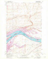
1962 Map of Paterson
USGS Topo · Published 1972About this map
Columbia River waters dominate this 1962 landscape, marking the border where Washington and Oregon meet. The map captures the river's character before and during significant hydrologic changes, showing Lake Umatilla and the complex channels around Bialock Island. On the Washington side, the small settlement of Paterson serves as a hub for the Burlington Northern railroad, while across the water in Oregon, the John Day Wildlife Management Area and Irrigon Cemetery sit near the riverbank. This survey provides a record of the regional infrastructure of the era, from the prominent pipeline crossings and aqueduct to the Paterson Ferry Road and Paterson Junction. The presence of an Old Railroad Grade and a Gaging Station highlights the long-standing importance of this corridor for transport and water management in the arid Pacific Northwest.
Find a feature on this map
23 named features on this map. Tap any name to fly to it.
Don’t see what you’re looking for? This feature index may not catch every label — zoom into the map to look around manually.
Map Details
Editions of this 1962 Paterson Map
2 editions found

Other maps of this area

1906 · Blalock Island
USGS Topo · 1:125,000

1908 · Blalock Island
USGS Topo · 1:125,000

1908 · Umatilla
USGS Topo · 1:125,000

1915 · Prosser
USGS Topo · 1:125,000

1917 · Pasco
USGS Topo · 1:125,000

1917 · Prosser
USGS Topo · 1:125,000

1953 · Pendleton
USGS Topo · 1:250,000

1953 · Walla Walla
USGS Topo · 1:250,000

1956 · Pendleton
USGS Topo · 1:250,000

1958 · Walla Walla
USGS Topo · 1:250,000