
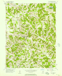
1956 Map of Patricksburg
USGS Topo · Published 1957About this map
Patricksburg serves as the central hub of this mid-century Owen County landscape, situated at the junction of the Monon Line railroad and several local roads. The town is flanked by evidence of the area's extraction economy, with several Strip Mines and a Strip Mine located just south and west of the settlement. The topographic data also captures a significant concentration of rural infrastructure, including the Township High Sch, indicating the town's role as a regional educational center during this era.
Find a feature on this map
43 named features on this map. Tap any name to fly to it.
Don’t see what you’re looking for? This feature index may not catch every label — zoom into the map to look around manually.
Map Details
Editions of this 1956 Patricksburg Map
2 editions found
Other maps of this area

1908 · Clay City
USGS Topo · 1:48,000

1908 · Bloomfield
USGS Topo · 1:62,500

1910 · Clay City
USGS Topo · 1:62,500

1938 · Coal City
USGS Topo · 1:24,000

1948 · Coal City
USGS Topo · 1:24,000

1950 · Arney
USGS Topo · 1:24,000
1953 · Coal City
USGS Topo · 1:24,000

1953 · Indianapolis
USGS Topo · 1:250,000

1956 · Indianapolis
USGS Topo · 1:250,000

1956 · Cataract
USGS Topo · 1:24,000