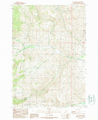
1989 Map of Pats Creek
USGS Topo · Published 1989About this map
Challis National Forest defines the high-country character of this Custer County landscape during the late 1980s. The drainage network is dense and intricately mapped, with Pats Creek and Challis Creek carving through the terrain alongside numerous seasonal and permanent flows like Eddy Creek and Darling Creek. The map documents a rugged environment where human activity is primarily industrial and remote, evidenced by several prospects and a Gravel Pit located in the southern reaches. High-altitude features like Jeffs Flats and Slab Barn Lake provide topographic context for the region, while the presence of Water Filtration Ponds near Garden Creek indicates the infrastructure required to manage resources in this high-elevation watershed. Navigation is limited to 4wd tracks and unimproved trails, emphasizing the area's isolation during this era of U.S. Forest Service management.
Find a feature on this map
24 named features on this map. Tap any name to fly to it.
Don’t see what you’re looking for? This feature index may not catch every label — zoom into the map to look around manually.
Map Details
Editions of this 1989 Pats Creek Map
This is the sole edition of this map. No revisions or reprints were ever made.
Other maps of this area

1929 · Bayhorse
USGS Topo · 1:125,000

1956 · Challis
USGS Topo · 1:62,500

1956 · Twin Peaks
USGS Topo · 1:62,500

1957 · Challis
USGS Topo · 1:250,000

1960 · Challis
USGS Topo · 1:250,000

1963 · Challis
USGS Topo · 1:250,000

1963 · Bayhorse Lake
USGS Topo · 1:24,000

1963 · Bayhorse
USGS Topo · 1:24,000

1963 · Clayton
USGS Topo · 1:62,500

1963 · Lone Pine Peak
USGS Topo · 1:62,500