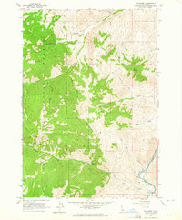
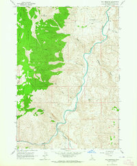
1963 Map of Bayhorse
USGS Topo · Published 1964About this map
Silver and lead mining history dominates this 1963 survey of the Salmon River canyon, where the settlement of Bayhorse sits deep within the gulches of the Challis National Forest. The landscape is heavily marked by the industrial footprint of the late 19th and early 20th centuries, featuring the Coke Ovens and numerous high-altitude workings like the Ramshorn Mine, Skylark Mine, and Pacific Mine. These sites are linked by a network of steep trails and jeep roads traversing peaks such as Ramshorn Mtn and Keystone Mtn. To the east, the Salmon River cuts through the terrain near Bayhorse Well, while the local Cem and Juliette Basin provide specific points of interest for genealogists tracing the families who worked these rugged claims.
Find a feature on this map
37 named features on this map. Tap any name to fly to it.
Don’t see what you’re looking for? This feature index may not catch every label — zoom into the map to look around manually.
Map Details
Editions of this 1963 Bayhorse Map
2 editions found
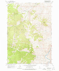
Other maps of this area

1929 · Bayhorse
USGS Topo · 1:125,000
1956 · Challis
USGS Topo · 1:62,500
1956 · Twin Peaks
USGS Topo · 1:62,500

1957 · Challis
USGS Topo · 1:250,000

1960 · Challis
USGS Topo · 1:250,000

1963 · Challis
USGS Topo · 1:250,000
1963 · Bald Mountain
USGS Topo · 1:24,000
1963 · Bayhorse Lake
USGS Topo · 1:24,000
1963 · Clayton
USGS Topo · 1:24,000
1963 · Clayton
USGS Topo · 1:62,500