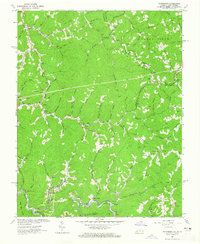
1964 Map of Patterson
USGS Topo · Published 1965About this map
The Norfolk and Western railway corridor along Dismal Creek defines the industrial character of this mid-century Appalachian landscape. This 1964 field-checked survey documents a region defined by coal extraction and timbering, centered on the settlement of Patterson with its industrial Tipple, Conveyor, and Mine Dump. Away from the rail lines, the terrain transitions into a dense network of family-named hollows and ridges, such as Chestnut Hollow and Bradshaw Mtn. These steep slopes are dotted with small-scale landmarks of local genealogy, including the Blankenship Cem, Wolford Cem, and Lower Big Branch Ch. Education in these isolated valleys is represented by the Big Butt Sch and Baker Ridge Sch, while the proliferation of Gas Well labels and the Spruce Mine indicates the continuing expansion of energy resources across the Virginia-West Virginia border.
Find a feature on this map
95 named features on this map. Tap any name to fly to it.
Don’t see what you’re looking for? This feature index may not catch every label — zoom into the map to look around manually.
Map Details
Editions of this 1964 Patterson Map
Other maps of this area

1886 · Grundy
USGS Topo · 1:125,000

1890 · Grundy
USGS Topo · 1:125,000

1891 · Tazewell
USGS Topo · 1:125,000

1892 · Grundy
USGS Topo · 1:125,000

1895 · Tazewell
USGS Topo · 1:125,000

1897 · Tazewell
USGS Topo · 1:125,000

1910 · Iaeger
USGS Topo · 1:48,000

1912 · Iaeger
USGS Topo · 1:62,500

1914 · Bucu
USGS Topo · 1:48,000

1914 · Iaeger
USGS Topo · 1:48,000