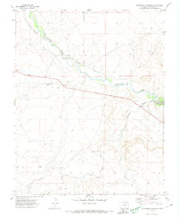
1971 Map of Patterson Crossing
USGS Topo · Published 1974About this map
Purgatoire River carves through this arid landscape in Las Animas County, where early water management is evident through systems like the Lewelling Mc Cormick Ditch and the Patterson Ditch. The terrain is defined by deep incisions such as Purgatoire Canyon, which dictates the movement of cattle and commerce across the high plains. The namesake Patterson Crossing serves as a critical point of navigation over the river, supplemented by technical markers like a Gaging Sta and a remote Cable Crossing.
Find a feature on this map
15 named features on this map. Tap any name to fly to it.
Don’t see what you’re looking for? This feature index may not catch every label — zoom into the map to look around manually.
Map Details
Editions of this 1971 Patterson Crossing Map
This is the sole edition of this map. No revisions or reprints were ever made.
Other maps of this area

1892 · Elmoro
USGS Topo · 1:125,000

1893 · Elmoro
USGS Topo · 1:125,000

1897 · Elmoro
USGS Topo · 1:125,000

1954 · Trinidad
USGS Topo · 1:250,000

1955 · Trinidad
USGS Topo · 1:250,000

1958 · Trinidad
USGS Topo · 1:250,000

1959 · Trinidad
USGS Topo · 1:250,000
1970 · Earl
USGS Topo · 1:24,000
1970 · Mooney Hills
USGS Topo · 1:24,000
1971 · Trinchera Cave
USGS Topo · 1:24,000