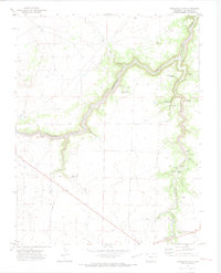
1971 Map of Trinchera Cave
USGS Topo · Published 1973About this map
The Purgatoire River carves a deep, winding path through this high-plains landscape in Las Animas County, serving as the central geographic feature for the surrounding canyons and waterholes. This 1971 survey highlights the remote character of the region, where life is defined by ephemeral water sources and isolated landmarks like the Million Dollar Waterhole. Notable cultural sites include the Los Hermanos Penitentes Cem, a burial ground associated with the historic Catholic lay fraternity, indicating the deep-rooted Hispanic heritage of the area.
Find a feature on this map
17 named features on this map. Tap any name to fly to it.
Don’t see what you’re looking for? This feature index may not catch every label — zoom into the map to look around manually.
Map Details
Editions of this 1971 Trinchera Cave Map
2 editions found
Other maps of this area

1891 · Mesa De Maya
USGS Topo · 1:125,000

1892 · Elmoro
USGS Topo · 1:125,000

1893 · Elmoro
USGS Topo · 1:125,000

1893 · Mesa de Maya
USGS Topo · 1:125,000

1897 · Elmoro
USGS Topo · 1:125,000

1954 · Trinidad
USGS Topo · 1:250,000

1955 · La Junta
USGS Topo · 1:250,000

1955 · Trinidad
USGS Topo · 1:250,000

1958 · La Junta
USGS Topo · 1:250,000

1958 · Trinidad
USGS Topo · 1:250,000