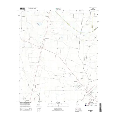
2014 Map of Patterson
USGS Topo · Published 2014About this map
Patterson and the smaller settlements of Aspinwall and Bristol anchor this portion of Pierce County, where the landscape is defined by the winding course of the Big Satilla Cr. This modern survey reveals a region deeply connected to its rural roots, evidenced by the numerous family and community burial grounds such as Aspinwall Cem, Tyre Cem, and Gethsemane Cem. The drainage pattern is intricate, with Sixty Foot Br, Fishing Cr, and Tan Trough Cr carving through the agricultural terrain.
Find a feature on this map
127 named features on this map. Tap any name to fly to it.
Don’t see what you’re looking for? This feature index may not catch every label — zoom into the map to look around manually.
Map Details
Editions of this 2014 Patterson Map
This is the sole edition of this map. No revisions or reprints were ever made.
Other maps of this area

1953 · Waycross
USGS Topo · 1:250,000

1958 · Waycross
USGS Topo · 1:250,000
1971 · Ritch
USGS Topo · 1:24,000

1971 · Coffee
USGS Topo · 1:24,000

1971 · Blackshear East
USGS Topo · 1:24,000

1971 · K'ville
USGS Topo · 1:24,000

1971 · Patterson
USGS Topo · 1:24,000
1971 · Screven
USGS Topo · 1:24,000

1971 · Blackshear West
USGS Topo · 1:24,000

1971 · Mershon
USGS Topo · 1:24,000