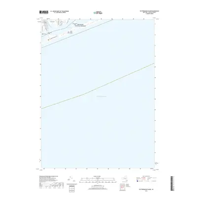
2019 Map of Pattersquash Island
USGS Topo · Published 2019About this map
Fire Island National Seashore dominates this coastal landscape, where the thin ribbon of Great South Beach separates the Atlantic Ocean from the inner coastal waters. The map highlights the maritime geography of Suffolk County, centered on the protected barrier island and the small, isolated Pattersquash Island located within Narrow Bay. To the west, the Narrow Bay Bridge provides the primary vehicular access to Smith Point, a vital link for those traveling to the shore via Fire Island Beach Rd. On the mainland, the residential development of Johns Neck is visible along the banks of Unkechogue Creek, defined by a grid of streets including Riviera Rd and Trafalgar Dr. This survey captures the delicate balance between recreational access and the preserved natural environment of the South Shore.
Find a feature on this map
15 named features on this map. Tap any name to fly to it.
Don’t see what you’re looking for? This feature index may not catch every label — zoom into the map to look around manually.
Map Details
Editions of this 2019 Pattersquash Island Map
This is the sole edition of this map. No revisions or reprints were ever made.
Other maps of this area

1903 · Riverhead
USGS Topo · 1:62,500

1904 · Riverhead
USGS Topo · 1:62,500

1904 · Moriches
USGS Topo · 1:62,500

1943 · Riverhead
USGS Topo · 1:62,500

1947 · Bellport
USGS Topo · 1:24,000

1947 · Howells Point
USGS Topo · 1:24,000

1947 · Eastport
USGS Topo · 1:24,000

1949 · New York
USGS Topo · 1:250,000

1954 · New York
USGS Topo · 1:250,000
1956 · Howells Point
USGS Topo · 1:24,000