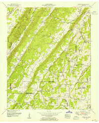
1952 Map of Pattie Gap
USGS Topo · Published 1954About this map
Paint Rock Ridge and Big Ridge dominate the topography of this Tennessee Valley region, where Roane, Loudon, McMinn, and Meigs counties converge. The 1952 field revision reveals a landscape of rural communities connected by creeks and gaps, including the namesake Pattie Gap and the nearby Morrison Store. Local social life in the mid-20th century centered on dispersed institutions like Dry Fork School, Luttrell School, and several country churches including Salem Church and Fenders Chapel.
Find a feature on this map
56 named features on this map. Tap any name to fly to it.
Don’t see what you’re looking for? This feature index may not catch every label — zoom into the map to look around manually.
Map Details
Editions of this 1952 Pattie Gap Map
This is the sole edition of this map. No revisions or reprints were ever made.
Other maps of this area

1887 · Kingston
USGS Topo · 1:125,000

1891 · Kingston
USGS Topo · 1:125,000

1893 · Kingston
USGS Topo · 1:125,000

1895 · Loudon
USGS Topo · 1:125,000

1935 · Niota
USGS Topo · 1:24,000

1935 · Rockwood
USGS Topo · 1:24,000

1935 · Philadelphia
USGS Topo · 1:24,000

1936 · Cave Creek
USGS Topo · 1:24,000
1936 · Sweetwater
USGS Topo · 1:24,000
1936 · Pattie Gap
USGS Topo · 1:24,000