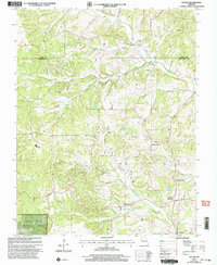
2000 Map of Patton
USGS Topo · Published 2003About this map
The rolling landscape of northern Bollinger Co at the turn of the millennium is defined by the headwaters of Whitewater Creek and its many tributaries, including Conrad Creek and Blue Creek. Small rural communities and crossroads like Yount, North Patton, and Patton Junction serve as the primary nodes of settlement along the winding road network. The map reveals a deeply rooted community infrastructure, with numerous country churches and schools dotting the drainages.
Find a feature on this map
27 named features on this map. Tap any name to fly to it.
Don’t see what you’re looking for? This feature index may not catch every label — zoom into the map to look around manually.
Map Details
Editions of this 2000 Patton Map
This is the sole edition of this map. No revisions or reprints were ever made.
Other maps of this area

1910 · Higdon
USGS Topo · 1:62,500

1923 · Perryville
USGS Topo · 1:62,500

1924 · Perryville
USGS Topo · 1:62,500

1933 · Marble Hill
USGS Topo · 1:62,500

1933 · Marquand
USGS Topo · 1:62,500

1937 · Marble Hill
USGS Topo · 1:62,500

1938 · Marquand
USGS Topo · 1:62,500

1949 · Paducah
USGS Topo · 1:250,000

1949 · Rolla
USGS Topo · 1:250,000

1950 · Paducah
USGS Topo · 1:250,000