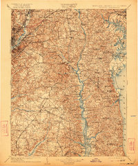
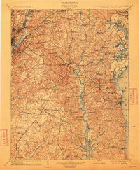
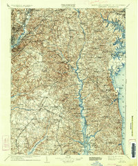
1906 Map of Patuxent
USGS Topo · Published 1921About this map
Annapolis and its waterfront dominate the northeastern corner of this study, which traces the tidewater landscapes and river-borne commerce of early twentieth-century Maryland. The Patuxent River bisects the region, flanked by crucial river crossings and landings like Magruder Ferry, Milltown Landing, and Deep Landing. These points, along with the Priest Bridge and Governor Bridge, underscore the importance of the river as both a barrier and a thoroughfare for the surrounding agrarian communities.
Find a feature on this map
151 named features on this map. Tap any name to fly to it.
Don’t see what you’re looking for? This feature index may not catch every label — zoom into the map to look around manually.
Map Details
Editions of this 1906 Patuxent Map
4 editions found

Other maps of this area

1889 · Fredericksburg
USGS Topo · 1:125,000

1890 · Mt. Vernon
USGS Topo · 1:125,000

1891 · Mt. Vernon
USGS Topo · 1:125,000

1892 · Leonardtown
USGS Topo · 1:62,500

1892 · Laurel
USGS Topo · 1:62,500

1892 · Fredericksburg
USGS Topo · 1:125,000

1892 · Drum Point
USGS Topo · 1:62,500

1892 · Prince Frederick
USGS Topo · 1:62,500

1892 · Brandywine
USGS Topo · 1:62,500

1892 · Owensville
USGS Topo · 1:62,500