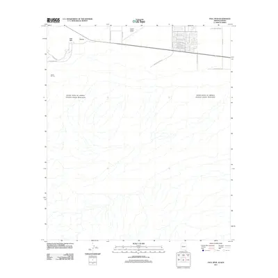
2011 Map of Paul Spur
USGS Topo · Published 2011About this map
The international border between the United States and Mexico dominates the southern half of this landscape, defining the rural character of the Cochise County desert. Just north of the boundary, the settlement of Paul Spur and the nearby site of Forrest sit along the primary east-west highway corridor. This area reflects a mid-century ranching and aviation footprint, anchored by the Cochise College Airport and historical ranching properties like Rancho San Jose. Local road names such as Wilbourn Ranch Rd and James Ranch Rd highlight the family-owned lands that have long defined this territory. To the northeast, a small residential street grid including Princeton Dr and Arizona State Dr indicates a cluster of development near the educational institution, while most of the quadrangle remains an open, arid expanse carved by numerous dry washes and drainages flowing south toward the border.
Find a feature on this map
22 named features on this map. Tap any name to fly to it.
Don’t see what you’re looking for? This feature index may not catch every label — zoom into the map to look around manually.
Map Details
Editions of this 2011 Paul Spur Map
This is the sole edition of this map. No revisions or reprints were ever made.
Other maps of this area

1902 · Bisbee
USGS Topo · 1:62,500

1910 · Bisbee
USGS Topo · 1:62,500

1914 · Douglas
USGS Topo · 1:62,500

1916 · Douglas
USGS Topo · 1:125,000

1919 · Douglas
USGS Topo · 1:125,000

1925 · Douglas
USGS Topo · 1:62,500

1927 · Bisbee
USGS Topo · 1:62,500
1933 · Douglas
USGS Topo · 1:62,500
1933 · Bisbee
USGS Topo · 1:62,500

1955 · Douglas
USGS Topo · 1:250,000