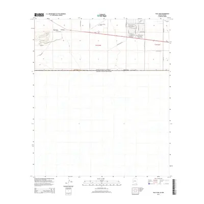
2014 Map of Paul Spur
USGS Topo · Published 2014About this map
The Arizona borderlands near Paul Spur and Forrest are defined by the strict east-west line of W International Rd, where the United States of America meets Mexico. This high-desert landscape is crossed by Az-80, which serves as the primary transportation artery for the region. To the north, the educational and aviation influence of Cochise Coll and the Cochise College Airport is visible, surrounded by a grid of streets named after prominent universities, such as W Notre Dame Dr and W Texas Christian Dr. Ranching history is preserved through rural access routes like Wilbourn Ranch Rd and N James Ranch Rd, reflecting the area's ongoing agricultural character. The terrain is marked by dry washes and gradual elevation changes typical of the Cochise County landscape, punctuated by local landmarks like N Stone Ridge Rd.
Find a feature on this map
40 named features on this map. Tap any name to fly to it.
Don’t see what you’re looking for? This feature index may not catch every label — zoom into the map to look around manually.
Map Details
Editions of this 2014 Paul Spur Map
This is the sole edition of this map. No revisions or reprints were ever made.
Other maps of this area

1902 · Bisbee
USGS Topo · 1:62,500

1910 · Bisbee
USGS Topo · 1:62,500

1914 · Douglas
USGS Topo · 1:62,500

1916 · Douglas
USGS Topo · 1:125,000

1919 · Douglas
USGS Topo · 1:125,000

1925 · Douglas
USGS Topo · 1:62,500

1927 · Bisbee
USGS Topo · 1:62,500
1933 · Douglas
USGS Topo · 1:62,500
1933 · Bisbee
USGS Topo · 1:62,500

1955 · Douglas
USGS Topo · 1:250,000