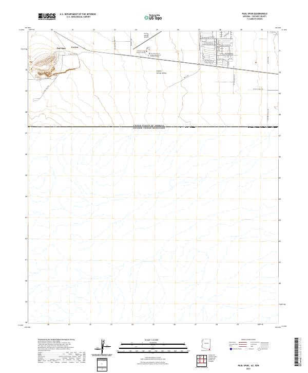
2021 Map of Paul Spur
USGS Topo · Published 2021About this map
The United States of America and Estados Unidos Mexicanos border line defines the southern character of this landscape, where the southern reaches of the Sulphur Springs Valley meet the international boundary. Higher ground to the west near Paul Spur and N Stone Ridge Rd transitions into a structured academic and residential grid centered on Cochise College. This area includes the Cochise College Airport and a series of streets named for universities, such as W Texas Christian Dr and W Notre Dame Dr, reflecting the institutional influence on the local development pattern north of Forrest. The layout suggests a planned community or educational hub situated just miles from the border crossing, accessible via Central Hwy and N Kings Hwy.
Find a feature on this map
37 named features on this map. Tap any name to fly to it.
Don’t see what you’re looking for? This feature index may not catch every label — zoom into the map to look around manually.
Map Details
Editions of this 2021 Paul Spur Map
This is the sole edition of this map. No revisions or reprints were ever made.
Other maps of this area

1902 · Bisbee
USGS Topo · 1:62,500

1910 · Bisbee
USGS Topo · 1:62,500

1914 · Douglas
USGS Topo · 1:62,500

1916 · Douglas
USGS Topo · 1:125,000

1919 · Douglas
USGS Topo · 1:125,000

1925 · Douglas
USGS Topo · 1:62,500

1927 · Bisbee
USGS Topo · 1:62,500
1933 · Douglas
USGS Topo · 1:62,500
1933 · Bisbee
USGS Topo · 1:62,500

1955 · Douglas
USGS Topo · 1:250,000