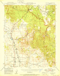
1950 Map of Paulden
USGS Topo · Published 1950About this map
Verde River headwaters emerge in this mid-century survey of Yavapai County, where the desert landscape is defined by ranching, rail, and the rugged drainage of Hell Canyon. The Atchison Topeka and Santa Fe railroad serves as the primary industrial artery, connecting the community of Drake and its Cedar Glade Ranger Sta to the scattered settlements of Abra and Puro. Water management is central to life in this arid region, evidenced by the Sullivan Lake reservoir and numerous stock tanks like Muldoon Tank and Schwanbeck Tank. The map documents a transition from the agricultural operations at Del Rio Ranch and Stewart Ranch Hdqtrs to the extractive interests shown by an Oil Well and the United States Mine. This record provides a clear look at the Chino Valley prior to late-20th-century development, capturing the layout of remote ranching outposts and high-desert infrastructure.
Find a feature on this map
40 named features on this map. Tap any name to fly to it.
Don’t see what you’re looking for? This feature index may not catch every label — zoom into the map to look around manually.
Map Details
Editions of this 1950 Paulden Map
2 editions found
Other maps of this area

1886 · Chino
USGS Topo · 1:250,000

1887 · Prescott
USGS Topo · 1:250,000

1891 · Chino
USGS Topo · 1:250,000

1892 · Prescott
USGS Topo · 1:250,000

1905 · Jerome
USGS Topo · 1:125,000

1922 · Williams
USGS Topo · 1:125,000

1944 · Clarkdale
USGS Topo · 1:48,000

1944 · Mingus Mountain
USGS Topo · 1:62,500

1947 · Mingus Mtn
USGS Topo · 1:62,500

1947 · Ash Fork
USGS Topo · 1:62,500